I would like to share a general approach to solving agglomeration development problems, which we have developed while working on an investment planning platform for urban development, using a digital twin.
The prerequisites for the challenges are a lack of thoughtfulness in the construction of new urban areas, which results in:
Creation of new city districts leads to a significant redistribution of traffic flows in the urban agglomeration as a whole and imperceptibly worsens the quality of life in the city.
Mathematical modelling techniques, which we summarise in the concept of a Digital Twin City, can be used to ensure that management decisions are thought-out, scenario analysis is carried out and optimal locations and functional purpose of the new areas are sought.
A comprehensive mathematical model of a city requires:
The prerequisites for the challenges are a lack of thoughtfulness in the construction of new urban areas, which results in:
- increased traffic congestion,
- lack of infrastructure,
- loss of competitiveness of the city as a whole and its individual parts.
Creation of new city districts leads to a significant redistribution of traffic flows in the urban agglomeration as a whole and imperceptibly worsens the quality of life in the city.
Mathematical modelling techniques, which we summarise in the concept of a Digital Twin City, can be used to ensure that management decisions are thought-out, scenario analysis is carried out and optimal locations and functional purpose of the new areas are sought.
A comprehensive mathematical model of a city requires:
- comprehensiveness of the assessment, including social, environmental and economic impacts, of the chosen (assessed) solutions
- coverage of the maximum number of factors for which there are statistical observations
- solving direct problems "what will happen if" (location of the housing or industrial site here)
- solving inverse problems "what would it take to get the maximum benefit for the city as a whole, rather than for the individual participants in the project
- using analytical, interpretable models based on very limited data sets for which the use of neural networks and machine learning is not available.
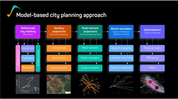
Our approach to building a comprehensive city model is as follows:
- First, an aggregated city model is created and calibrated, linking the performance of key areas of the city over time. I have written earlier about the concept of this model Referenced City Model, and we gradually put its implementation for 3,000 cities here. Having this model and keeping it up to date allows us to already take the next steps to solve spatial problems.
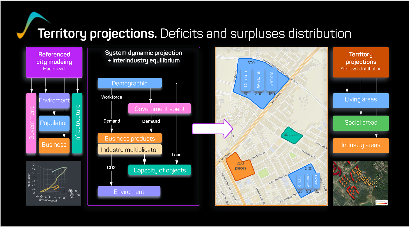
(Сalculating points of supply and demand, deficits and surpluses)
2. Projection of macroeconomic data to particular areas and sectors of the city, based on indirect (buildings and constructions) or subject (organizations) data:
- area characteristics and functional purpose of buildings,
- number of residents and employees
- consumption of energy resources
- all the information available to us.
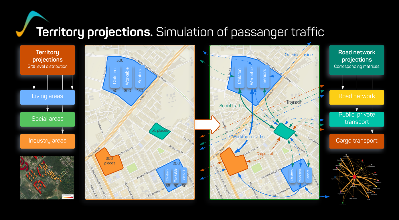
(Evaluation of traffics as-is)
3. Creation of a computational model of transport flows of passengers and goods between places of residence, work and services, cargo flows between places of production.
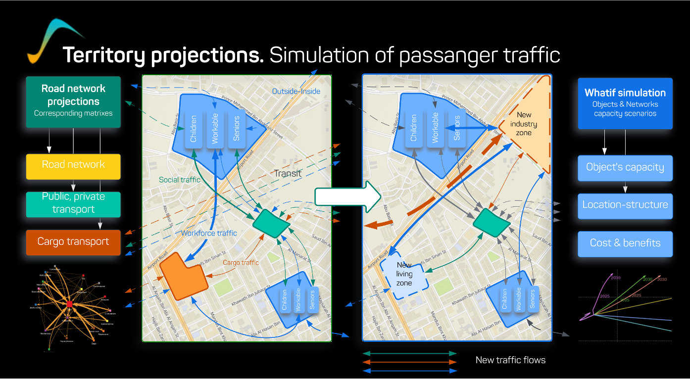
(What-if modelling of traffic flows)
4. On the basis of the macroeconomic, spatial and transport model, conduct a scenario analysis of the creation of buildings and constructions in a particular part of the city. The result of this analysis is the impact on the main macroeconomic, spatial and transport indicators. What is important here is the scenario calculation of summary indicators - the impact on the rate of socio-economic development. (The choice of this indicator is one of the most interesting tasks and is worth writing about separately).

(Cost & benefits analyses)
5. As a result of defining the target indicator and identifying the constraints, we move on to the final part - the search for the optimal solution, taking into account the unfolding of the project over time.
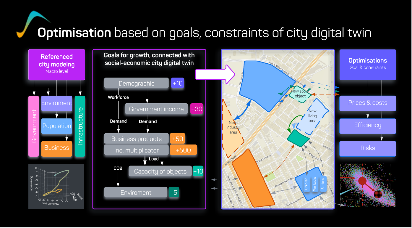
(Finding optimal placement for functional zones)
Each of the above steps is implemented with a set of mathematical models, calibration, prediction and optimisation calculations. We implement the mathematical models in the form of author's libraries in the R Posit environment. The set of models includes:
Of course, we are very dependent on completeness of data, but it is the models that help us to fill data gaps and increase the credibility of our intuitive decisions by testing their validity on historical data sets.
Using this approach, infrastructure project specialists at investment banks & government organizations can make better-informed and more effective decisions that contribute to sustainable urban development and competitiveness.
- system dynamics and wave models,
- models of inter-industry and inter-territorial balances (input-output models),
- thermal models for solving problems of projection of calculations on territories.
Of course, we are very dependent on completeness of data, but it is the models that help us to fill data gaps and increase the credibility of our intuitive decisions by testing their validity on historical data sets.
Using this approach, infrastructure project specialists at investment banks & government organizations can make better-informed and more effective decisions that contribute to sustainable urban development and competitiveness.